Yachiyo Engineering Co., Ltd.
Menu
Menu

2020.10.05
Yachiyo Engineering has partnered with Hitachi Triple Win Corp. (President and CEO: Masami Aishima, headquartered in Minato, Tokyo), Aerialphoto Service Co., Ltd. (President and CEO: Tetsuo Yamamoto, headquartered in Minato, Tokyo), and K- PAX Co., Ltd. (CEO: Yoshihiko Kawachi, headquartered in Sakura, Chiba) for the joint development of a new service called "DamLook."
This service combines dam inspection and diagnostic know-how with UAV operation and aircraft control technology to greatly improve efficiency in the aerial photography of dams through the autonomous navigation of UAV s, while also improving the quality and reproducibility of the acquired image data.

Background
GPS positioning information usually has a low level of accuracy in mountainous valleys due to low satellite coverage and the multi-pathing that occurs near tall structures such as dams. This makes it impossible for unmanned aerial vehicles (UAV) to fly autonomously using GPS information. Therefore, since the GPS positioning and attitude controls of UAV s are not effective, pilots have had to manually maneuver the UAV close to the dam and use the UAV'S onboard digital camera to take aerial photos of it.
As a result, the images were dependent on the pilot's experience and operational skill, which sometimes cause quality issues to arise, including uneven, blurred, or omitted images. This also affected accuracy in the inspections and diagnostic analyzes that utilize artificial intelligence (AI) Pilots thus have a large burden to bear, and UAV s have not been labor-saving nor have they improved efficiency, despite being a key technology for improving productivity.
Features of Dam Look
In light of these issues, the newly developed DamLook has four features that significantly improve efficiency in the aerial photography of dams for inspection, diagnosis, and management. It also improves the quality and reproducibility of the acquired image data.
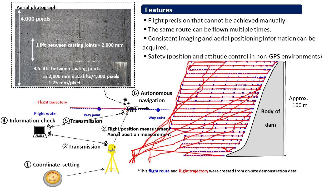
(1) Application of autonomous UAV navigation to dams using total stations (TS)
Opportunities to use autonomous UAVs using TS have been limited due to restrictions imposed on flight altitude and control when general-purpose aircraft are used. Therefore, in order to apply the technology for large structures such as dams, we performed multiple field tests and made improvements , leading to successful autonomous UAV navigation around dams with a level of flight precision and safety that cannot be matched by manual operation. Additionally, since flights can be managed with absolute coordinates through the use of TS, the technology works well with surveying results, and is thus suitable for dam management.
(2) Autonomous flight routes at a standard distance from the dam can be produced
General piloting software often does not reflect the three-dimensional topography of the body of the dam and does not allow for a detailed autonomous flight route to be set. Therefore, by using the fact that position and attitude control is possible for UAV s tracked by TS, even those being operated manually, a function to create a route from that stable flight trajectory was implemented. As a result, once the UAV is flown with the DamLook service, it can make repeat flights to the same place in the future, which will improve consistency and prevent missing shots.
(3) High-resolution photography with clear and consistent images is possible
An autonomous flight path that maintains a standard distance from the dam helps stabilize the aircraft while in flight, enabling high-resolution aerial imaging of the entire dam that is clear and consistent. This standardized and clear high-resolution image data is useful for AI- based inspection and diagnostic analysis.
(4) Geotag information can be added to images even when flying in non-GPS environments
Automatic tracking of the UAV using TS also allows for the measurement of aerial shooting positions, which improves the accuracy of the 3D restoration process performed with 3D modeling software.
■ Conceptual image of the service
The new DamLook will be offered beginning with the basic functions of the service, with additional functions added gradually in the future. We can also provide a total support package using our AI for inspection, diagnosis, and management along with the captured images.
Contact for inquiries about DamLook: riips-digitalization@yachiyo-eng.co.jp