Menu
Overview
In Japan, dam body surfaces are inspected visually for deterioration. There are numerous issues with this process: Differences in inspecting engineer ability, which can lead to inconsistent evaluations and omissions, affecting inspection accuracy and reproducibility; determining the distribution and size of damage across the entire dam body; and the many risks of work at height.
DamLook is a service that aims to improve inspections and save labor by replacing the conventional close-up visual inspections for dam body deterioration by inspection engineers with digital inspections that combine aerial imagery by autonomously piloted UAVs and deterioration extraction by deep learning with AI.

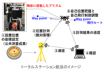
Autonomous UAV piloting using a total station and deep learning for dam body degradation surveys
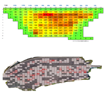
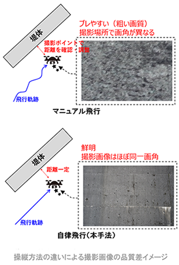
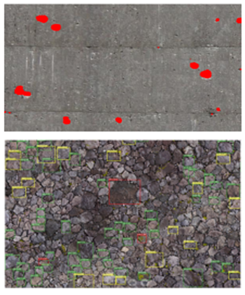
For dams in narrow mountainous areas, the accuracy of satellite positioning is uncertain. As such, we have applied UAV self-positioning estimation technology with a total station to enable high-precision autonomous flight. By aerially photographing the entire dam body surface uniformly in high resolution from an equal head-on distance, this makes it possible to capture image data useful for AI image recognition. Using deep learning on the huge amount of captured image data, image recognition detects deterioration information automatically. By manually marking degraded sections in some of the captured images, the deterioration detection AI can learn how humans detect deterioration, enabling it to automatically detect deterioration in the entire dam body and saving work in dam body surveys. The detection results can be used in combination with photogrammetry techniques to calculate position and magnitude of deterioration and quantitatively assess deterioration in each sector of the dam body to serve as basic data for dam health assessments. With continuous surveying over multiple years, results can also be compared over time.
The total station records tracking and measurement positioning information for a prism mounted on the UAV and feeds it back to the UAV, enabling the UAV to recognize its own position and fly autonomously
Aerial photography taken by UAV in autonomous flight at stable attitude and positions
Automatic extraction of deterioration points across the entire dam body with deterioration detection AI
Quantitative assessment of deterioration in each sector of the dam body can be used as basic data for dam health assessments