
Menu


Overview
Nowadays plastic pollution is recognized as an important environmental issue that needs to be addressed globally. One of the targets of Sustainable Development Goal (SDG) 14 is to prevent and significantly reduce marine pollution, specifically considering the index of floating plastic debris density as an official indicator for such environmental goal.
Majority of marine debris come from land-based activities and flow via the river and into the ocean. In view of this, Yachiyo Engineering introduces RIAD or River Image Analysis for Debris Transport, a smart application that enables users to understand the actual situation of floating or riverine debris such as plastics and raise awareness on this environmental issue.

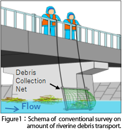
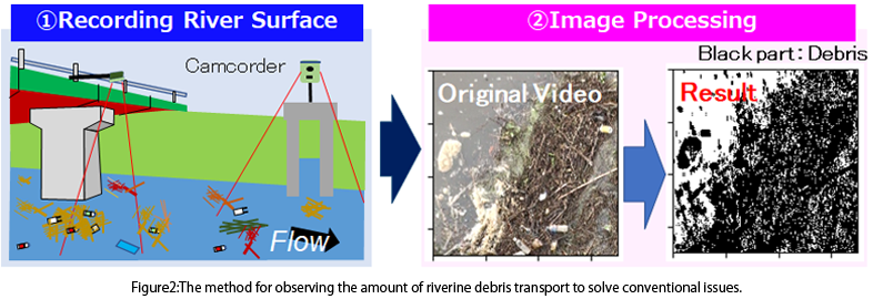
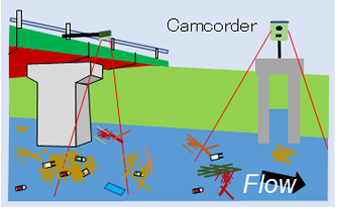
When it rains, or the water level rises, you can see more riverine debris flowing. Conventionally, riverine debris surveys have been conducted by visual inspection or sampling (refer to Figure 1), but these methods bring about heavy workloads and safety issues. To address these issues, we developed a method for observing the amount of riverine debris transport through video recording of riverine surface and image processing of the recorded video (refer to Figure 2). We utilized the research results of Professor Yasuo Nihei of Tokyo University of Science and Associate Professor Tomoya Kataoka of Ehime University (※1) for the observation method and in developing new technology for image processing. Finally, we succeeded in commercializing RIAD as a software for measuring debris transport amount.
With recorded video of the river surface, this technology enables you to respectively grasp the amount of anthropogenic
debris such as plastics and natural debris such as driftwood. This technology was featured at the “G20 Ministerial Meeting on Energy Transitions and Global Environment for Sustainable Growth” as an innovative case study.(※2)
※1:Kataoka, T. and Nihei, Y.: Quantification of floating riverine macro-debris transport using an image processing approach. Scientific Reports, Vol.10, pp.1-11, 2020.
※2:MOE (Ministry of Environment):http://www.env.go.jp/earth/20190613brochure.pdf
You just simply upload the recorded video to the cloud and set the initial conditions such as processing range. Image processing is then performed.
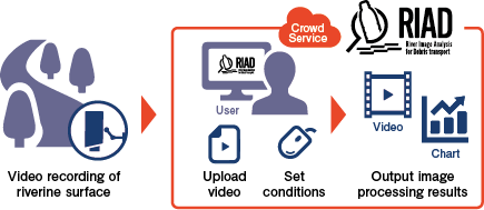
・It is possible to measure the amount of river debris transported simply by taking a video of the river surface with a camera.
・Compared to the existing observation method of direct sampling, the safety and certainty of the observation method can be greatly improved.
・You can monitor on the system that the area transport amount of natural and anthropogenic debris changes over time. In addition, processed data can be downloaded or output as a chart. The system allows you to monitor changes in an area transport volume of natural and anthropogenic debris over time. The processed data can be downloaded and presented as a graph/ chart.
・The processed results of extraction of river debris can viewed on the video.
・Advanced settings such as changing the conditions of extraction of river debris can be supported.
・We hold briefing sessions on system operations and instructions for users.
・Image processing of river debris transport amount is conducted with the RIAD system.